Tag: Earth

  • Hubble Telescope Captures Spectacular New Images of Tarantula Nebula

    Hubble Telescope Captures Spectacular New Images of Tarantula Nebula

    WASHINGTON — New views from the Hubble Space Telescope are revealing the spooky-looking Tarantula Nebula in never-before-seen detail.
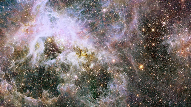
    The Tarantula Nebula is located about 160,000 light-years from Earth in the Large Magellanic Cloud, one of the closest galaxies to the Milky Way. The prolific Hubble Space Telescope produced the image, which shows multicolored clouds of gas and dust glowing with stars sprinkled throughout the image.

    Hubble officials previously released images of the spidery nebula, however, this is the deepest view of the intriguing cosmic region full of star clusters yet. [See the amazing new Tarantula Nebula photos]

    “The image is dominated by gas and dust, but I can assure you that there are more than 800,000 stars living in this region,” Elena Sabbi, of the Space Telescope Science Institute, said as she unveiled the new image here at the 223rd meeting of the American Astronomical Society. “To see them, you have to strip away the veil the dust is causing and then you can admire the stars in this region. This is a very efficient way to identify where stars are forming nowadays in the Tarantula Nebula.”

    The impressive star cluster located on the left center portion of the image is actually a super star cluster called R136. The massive group of stars could eventually become a globular cluster — bunches of old stars orbit the centers of their galaxies.

    Much of the Tarantula Nebula’s visibility is actually due to R136 thanks to the amount of energy produced by the super star cluster.

    The image was created as part of the Hubble Tarantula Treasury Project, an initiative to map stars within the nebula in order to understand its structure more thoroughly. The Tarantula Nebula represents an environment that could be similar to the extreme conditions that existed during the early universe, Hubble officials said.

    The new image is also used in an electronic book called Reach for the Stars: Touch, Look, Listen, Learn. While the new book is designed for children for visual impairments, anyone can use it to explore the complex nebula. The book will be available for free on iPad.

    “We hope it will be an inspiration and attract people to science,” Sabbi said in a statement. “That’s the main goal. We want to convince children that science is cool, is fun, and that anybody could be a scientist, if they want to.”
    Link to original source

  • Exclusive Images of the Earth from Space

    Exclusive Images of the Earth from Space

    Ever wondered what the earth might look like when viewed away from the planet? It is always a great filling to see what the planet we live in looks like. Here is your opportunity to browse through image of the earth take from the space.

    Out of the 55 images published by mashable.com, We have have chosen 10 most exclusive images from the gallery.

    A description is attached below each image, feel free to share your views and opinion on the comment section. To enlarge any of this images, simply click on it.

    1. Florida Keys

    Taken Dec. 5, 2003 by the Moderate Resolution Imaging Spectroradiometer (MODIS) on the Aqua satellite.

    2. Reefs in Princess Charlotte Bay

    Taken April 20, 2013 by the Operational Land Imager (OLI) on Landsat 8. These formations are part of the Great Barrier Reefs in Australia. This area lies on the east coast of Queensland’s Cape York Peninsula.

    3. Fires in Cuba and Florida

    Taken Feb. 3, 2003 by the Moderate Resolution Imaging Spectroradiometer (MODIS) on the Aqua satellite. Fires are marked in red.

    4. Steam Plume from Gaua Volcano

    Taken May 31, 2013 by a member of the International Space Station crew using a Nikon digital camera. Located in the Pacific Ocean, Gaua island is the top of a stratovolcano part of the Vanuatu Archipelago.

    5. Korangi, Pakistan

     Taken April 20, 2013 by a member of the International Space Station crew using a Nikon digital camera. 

    6. Little Rock, Ark.

     Taken May 24, 2013 by a member of the International Space Station crew using a Nikon digital camera. 

    7. Intersection of the Danube and the Black Sea

     Taken Feb. 5, 2013 by the Advanced Land Imager (ALI) on the Earth Observing-1 (EO-1) satellite. 

    8. Hurricane Sandy

     Taken Oct. 30, 2012 by the Visible Infrared Imaging Radiometer Suite (VIIRS) on the Suomi NPP satellite. The image is rotated, looking south from Canada — north is at the bottom of the image. 

    9. Istanbul at Night

     Taken on Aug. 9, 2012 by a member of the International Space Station crew using a Nikon digital camera. 

    10. Northern Lights

     Taken on Sept. 17, 2011 by a member of the International Space Station crew using a Nikon digital camera.